Visualization
examples
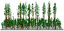
Geometric model:
stand scale
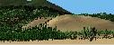 Geometric model:
landscape scale
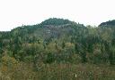
Geometric model:
landscape scale
 Video imaging:
original image
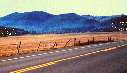
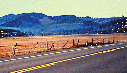
Video imaging:
original image
 Video imaging:
after modification
to add harvest unit
Video imaging:
after modification
to add harvest unit
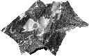
 Geometric video
imaging: wireframe
model
Geometric video
imaging: wireframe
model
 Geometric video
imaging: original
photograph
Geometric video
imaging: original
photograph
 Geometric video
imaging: retouched
image
Geometric video
imaging: retouched
image
 Orthophoto draped
over a digital
terrain model
Orthophoto draped
over a digital
terrain model
|
The appearance of landscapes and individual stands
after harvest operations is critical to public acceptance of
timber harvest practices. Thorough planning, detailed
site-specific analysis, and careful monitoring of harvest
activities will not result in truly successful operations if
the public views the resulting landscape as an eyesore.
Activities intended to mitigate the visual impact of
harvests include modifying unit boundaries to conform to
topography and other natural stand openings, prescribing
silvicultural treatments that retain higher numbers of
standing trees or groups of trees, and attempting to "hide"
or "screen" harvest units from sight. These mitigation
efforts can be successful. However, foresters charged with
designing harvest unit shapes and silvicultural treatments
often find it difficult to develop visually acceptable
solutions by working in the field or with planimetric maps
and aerial photographs. Visualizations depicting the
appearance of a treatment or harvest operation provide
important feedback during the design process and help to
communicate management intentions to resource specialists
and public stakeholders.
Forestry professionals have used visualization techniques
to address a variety of forest management problems. Prior
to the advent of computerized methods, they used "artists'
renditions" to communicate the effects of land management
activities. Perspective sketches and scale models continue
to help communicate the spatial arrangement and extent of
management activities to the lay public. However, current
practices in forest management involve more detailed
harvest designs involving small treatment areas scattered
over larger landscapes and the removal or modification of
specific stand components. Alternative treatments utilize
different mechanical methods, vary the spatial arrangement
of treatment units, and specify different levels of
modification within individual treatment units. With such
treatments, the traditional "artists' rendition" cannot be
made specific enough to represent the subtle differences
between alternative treatments.
Computerized visualization methods range from simple
diagrams to complete virtual realities. Four methods are
commonly used to produce visual representations of forest
operations: geometric modeling, video imaging, geometric
video imaging, and image draping.
Geometric Modeling
Geometric modeling methods build geometric models of
individual components (ground surface, trees, other plants,
and structures) and then assemble the component models to
create an image of a forest stand or landscape. Scenes
depicting the complete model are then rendered from a
variety of viewpoints. In its simplest form, this technique
can be used to generate perspective drawings showing typical
GIS data coverages such as roads, streams, and polygon data
overlaid onto the ground surface. More complex applications
build detailed models of individual trees that include small
branches and leaves for use in rendering.
Video Imaging
Video imaging uses computer programs to modify scanned
full-color video or photographic images to represent changes
to stand and landscape conditions. Video imaging produces
television-quality (or better), full-color visual
representations that depict current and future conditions.
Video imaging typically requires a library of images
representing different forest conditions to replace portions
of an original image, however, direct manipulation of images
is also possible.
Geometric Video Imaging
A hybrid approach, termed geometric video imaging for this
discussion, combines geometric modeling and video imaging
techniques to produce very realistic images that accurately
represent data describing the effects of forest management
activities. Operators use geometric modeling to produce
scenes that specify the location, arrangement, and scale of
proposed landscape changes. Video imaging is then used to
modify a digitized image to reflect these changes. The
technique can be extended to use geometric modeling to
determine the locations for digitized images, or icons, of
single trees. Hybrid approaches result in images that
accurately reflect the data describing proposed changes.
However, to produce photo-like images, hybrid techniques
require extensive libraries of tree and stand images that
represent an appropriate range of species, tree sizes,
growth forms, and landscape positions.
Image Draping
Image draping mathematically "drapes" an image over a
digital terrain model and then renders the resulting scene
from a variety of viewpoints. Operators usually obtain the
image from a satellite scene, aerial photograph, orthophoto,
or map sheet and use techniques common to video imaging to
modify the original image to reflect management activities.
Several GIS and image processing applications provide
draping capabilities. Most include rectification procedures
to properly orient and align a digital image to the ground
surface. Simple applications utilize orthophoto images that
have already been registered to the ground surface and
corrected for elevation, or relief, displacement. |