|
Canopy Fuel Estimator
(CFE); |
|
| Home |
USDA Forest Service, Pacific Northwest Research Station |
|
Canopy Fuel Estimator
(CFE); |
|
| Home |
USDA Forest Service, Pacific Northwest Research Station |
The canopy fuel estimator is no longer available for download. Basic fuel estimation options are available in the GridMetrics program within the FUSION/LDV analysis and visualization software package.
|
To assist resource managers in the use of LIDAR to characterize canopy fuels over the landscape, a new LIDAR processing tool titled the Canopy Fuel Estimator (CFE) has been developed by researchers at the USDA Forest Service, Pacific Northwest research Station and the University of Washington, College of Forest Resources. The overall objective of the Canopy Fuel Estimator (CFE) is to use data from airborne laser scanner (small-footprint LIDAR) systems to characterize fuel conditions over extensive land areas. The primary reference for the methodology is Andersen et al. (2005b). Processing is accomplished in a raster environment using input layers and ground surface models derived from LIDAR point data. While the CFE is primarily designed to estimate canopy fuel parameters, its design is flexible enough to support a variety of analysis tasks that involve LIDAR point data, production of data layers derived from the point data, and, optionally, application of a “model” to predict a variable of interest. CFE overviewCFE computes LIDAR-derived variables for the maximum, mean, and coefficient of variation of the LIDAR canopy heights, several quantile-based metrics describing the LIDAR canopy height distribution, and a canopy density metric. The CFE includes models that use these LIDAR-derived variables to predict canopy fuel weight, crown bulk density, canopy base height, and canopy height over the landscape. Models included with the CFE are applicable to forests in western and eastern Washington. Additional models can be defined using a combination of LIDAR-derived metrics and either pre-defined or user-supplied model forms. The CFE reads industry-standard LAS LIDAR data files and produces raster output that is compatible with most Geographic Information System (GIS) environments. The CFE is designed as a stand-alone program that uses a graphical interface to guide the user through data processing and analysis. CFE is designed in such a way that it can be “connected” to ArcMap at a later date. This connection will most likely consist of adding a menu option or button to ArcMap that launches the CFE and providing the ability to create an ArcMap project that includes the input data, intermediate data products, and final outputs as layers in the project. The CFE will perform its own processing without relying on ArcObjects but will interact with ArcObjects to access and manage the ArcMap project. Output from the CFE is a series of new spatial data layers that describe fuel characteristics and the distribution of forest canopy over the project area (Figure 9).
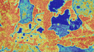
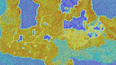
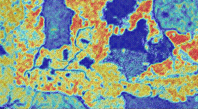
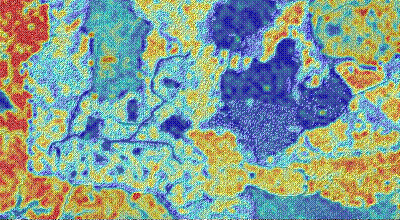
Canopy fuel maps (30 m resolution), Blue Ridge Silvicultural Options Study site. LIDAR-derived canopy metrics and canopy fuel layersThe LIDAR points used for all derived canopy metrics is the set of LIDAR returns that are 2 meters (user defines this canopy threshold height) or more above the LIDAR bare-ground surface. This subset of LIDAR returns represents “vegetation points”. The following variables are computed using the raw LIDAR point data and the bare-ground surface model.
CFE OutputThe following spatially explicit canopy fuel layers are generated from the LIDAR-derived canopy metrics in a GIS-compatible raster format.
ReferencesAndersen, H.-E., R.J. McGaughey, and S.E. Reutebuch. 2005b. Estimating forest canopy fuel parameters using LIDAR data. Remote Sensing of Environment 94(4):441-449. |
This page was last updated on June 11, 2018 by Bob McGaughey